contact | home | where is Salthouse? | Salthouse book | editor| site map | news
alphabetical list | groups | Brown | Cooke| Dawson | Dix | Hancock | Hayward | High | Holman | Pigott | Woodhouse |
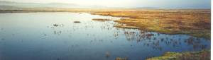
village | church | 1583 buried records | marshes| heath | mystery windmill | Rocket house |
slide show | 1897 | 1938 | 1949 | 1953 page1| 1953 page2 | 1993 | 1996 |
 Salthouse
marshes page
2 Salthouse
marshes page
2 back to previous page |
||||||||||||||||||||||
The fact remains that till the death of Elizabeth I seagoing vessels used to sail to Salthouse, Kelling and even Weybourne via the Salthouse Main Channel, whose course has been described. All through the Middle Ages a considerable export of wool and corn to the Low Countries, and import of manufactured goods from the Continent, was carried on by Salthouse ships and sailors trading with the Hansa towns. It has often been said that the fine churches of Norfolk were built from the profits of the wool trade; and it was from the small ports of the north coast that most of it was done. In a Muster Roll of 1570 there is the following table:
From this it must be
reasoned that in 1570 the encroachment of the sea was already making
the Salthouse Main Channel almost unnavigable for anything but the
smallest of craft, called in those days 'doggers' (the name has survived
in the Dogger Bank), and it is known that the Salthouse mariners
beached their small boats on the south bank of the Main Channel at
a point in the extreme north-west of the parish, opposite Walsey
Hills, called 'Dogger Layer Point' in an early seventeenth-century
chart of the marshes. This point would appear to have been about
100 yards east of Cley East Bank and 70 yards south of the 1855 sea
wall. In 1621 there began a
perfect orgy of reclamation of marshland throughout the east of England.
This was probably caused by the Thirty Years War which occasioned
a cessation of practically all husbandry on the Continent where there was
burning and ravaging from one end to the other. The demand for English
produce in the devastated areas must have been great, and consequently
there was a great call for good corn land, with the result that the
Fens were drained between 1621 and 1640.
|
brackish through its being open to the ebb and flow of the tides, the authorities set a Dutchman named Van Hasedunck to work in 1637. He threw up a bank in that year from a point close to where the Dun Cow Inn now stands, for about 150 yards due north, and then bent his line north-east, straight for Little Eye. He then built a dam between Little Eye and Great Eye, exactly where the present owner has just built a causeway for a road. [This causeway, built in the 1930s, lies under the sea in 2004.] One result of this banking work was a series of lawsuits. It seems that Van Hasedunck had not sufficiently sluiced his enclosed marshland, with the result that instead of it being only submerged at spring tides (with tidal brackish water) it was perpetually covered with the flow of fresh water from Weybourne Stream and Kelling Beck. Lady Sidney, as owner of Gramborough Hill (where there was undoubtedly a windmill), went to law with the complaint that: the said new embankment made over the mayne channel between the great and little eyes stopped and penned up the fresh water flowing from Waborne Mill and Kelling becke that the said Ladie cannot feed her grounds lying on the North side of the mayne channel which always have been known to be the right of the town of Salthouse . . . The inhabitants are excluded from 'their fishing in the said channel and crick' . . . and from the sea 'Their chief means of livelihood' and . . . are forced to beg and seek new habitations. Unfortunately there is no record of the results of the lawsuits, and perhaps with the death of Lady Sidney they were not pressed to a decision. In any event reclamation was so much the fashion of the day that it was probably heresy to object, for in 1649 a new bank was built from the east end of Walsey Hills due north to the seabeach, and one was also constructed east and west from the middle of this north and south bank (its point of junction would now be close to the southward of the 1855 sea-wall) to join up with the Cley embankment. So that after 1649 the only part of the Salthouse Main Channel left with communication to the open sea was in the extreme north-west of the parish at Dogger Layer Point. As late as 1850 a resident of Blakeney, now [Commander Stagg is writing in 1931, don't forget] recently dead, stated that he had sailed his boat round the north end of Cley East Bank as far as Dogger Layer Point. Just north of Walsey Hills was an enclosed portion known as Little Harnser Marsh in 1649, then (as recently) the home of herons.
|
|||||||||||||||||||||
