The North Norfolk village with the Fascinating History
SALTHOUSE

   
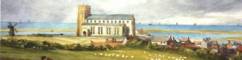
from the heath c 1820  

The churchwarden went up the tower and took photos to the west, north and south of the village

Here,  looking towards the west through the battlements of the tower, we see the shingle bank in the distance which is all that keeps the sea from rushing over the marshes when wind and tide are  high.

60-70 years ago, the marshes were nearly always flooded to a depth of several feet  in the winter months.


In the foreground, you can see  the Dun Cow and the post office and the cluster of houses round the village green.
To see them in close-up, go back to the homepage  and choose the village map (or click here to go direct). The map is full of hotspots which - when you find them by moving the mouse about - can be selected to show old post card views  of different parts of the village.

Back to views from the tower selection page

© Val Fiddian 2005