Salthouse Marshes
page 3 or back to the start of this article
Salthouse Marshes
page
3 or
back
to the start of this article
|
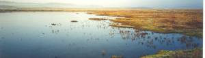
the northern end of Cley East Bank to Kelling Hard. But six years later, in 1861, a storm breached it once more and Salthouse Broads (as the western portion of the marshes is known) again became brackish. Kelling Beck was then diverted through a new channel which runs alongside the Coast Road and out of Salthouse parish just before reaching a sluice in Cley East Bank. But new cuts are necessary from time to time, and there will surely come a day when a repetition of the storm of 1897 will have let the sea into this picturesque tract of marsh to such an extent that either drainage or reclamation will be rendered impossible. There is in the possession of a neighbouring squire a free-drawn sketch of Salthouse Marshes in the year 1733. It shows the Salthouse Main Channel as a considerable waterway with a large tract of land to seaward along all its course [whereabouts now, sadly, unknown].
|
On the north side of this Channel there is drawn not merely Lodge Hill (Great Eye) with a red and white striped structure on it (presumably a beacon) but four other hillocks or ‘eyes’ rising from the marshes. Gramborough Hill appears well inland, whilst to the westward of Great Eye and to the north of the Channel (which is then called Ruburgh Channel) is a marsh called ‘Eighteen Acres’ and to the westwards of that again is ‘Mr Lang’s Marsh’, in the extreme north-west of Salthouse parish. It is interesting to note that Blakeney parish boundary is marked along the west side of ‘Mr Lang’s Marsh’, and thus Blakeney abutted Salthouse until all the land to the north of Ruburgh Channel was swallowed up by the sea—probably since the middle of the nineteenth century. On the south side of Salthouse Main and Ruburgh Channels a ‘New Bank’ had been constructed in 1733, along its whole course, and this bank continued along the parish boundary between Ruburgh Channel and Walsey Hills. Between Cley East Bank and Salthouse Boundary Bank there is marked ‘Mr Thos. Royall’s Marsh’ in Cley parish. The above is the last chapter of 'A History of the Parish of Salthouse in the County of Norfolk' by Commander Frank Noel Stagg, published as the first part of the book: Salthouse, the story of a Norfolk village, produced by the Salthouse History Group. |