groups
alphabetical name index
Brown
Cooke
Dawson
Dix
Hancock
Hayward
High
Holman
Lynn
Pigott
Woodhouse
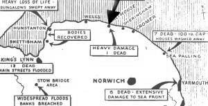
WHERE IS SALTHOUSE?
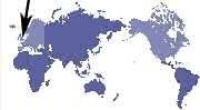
With this supply of maps, there is no excuse for not knowing where Salthouse, Norfolk, UK is to be found!
Even if the UK is a bit small . . . you can still see where abouts it is located. . .
SALTHOUSE lies on top of the bulge of EAST ANGLIA
Click here to go to multimap.com
and see their map of Salthouse, weather reports and much much more.
| |
 |